About the projected future changes in river flows across Peninsular Malaysia
The Hydrological Modelling Framework — Peninsular Malaysia (HMF-Malaysia: Rameshwaran et al., 2022) provides grid-based and spatially-consistent simulations of river flows at a 0.008333° × 0.008333° grid (approximate grid of 1 km × 1 km) resolution across Peninsular Malaysia.
HMF-Malaysia uses rainfall and temperature data as input. Here the CORDEX-SEA ensemble provides daily climate model output, consisting of precipitation, daily near-surface air temperature and/or maximum and minimum near-surface air temperature were used. The CORDEX-SEA climate scenarios considered were RCP2.6, RCP4.5 and RCP8.5 with 6, 7 and 13 ensemble members respectively (Rameshwaran et al., 2022).
In HMF-Malaysia, anthropogenic water transfers between rivers are included in the model. Two scenarios of artificial influences are considered:
- current artificial influences (CAI) such as water transfers and diversions
- planned future artificial influences (FAI).
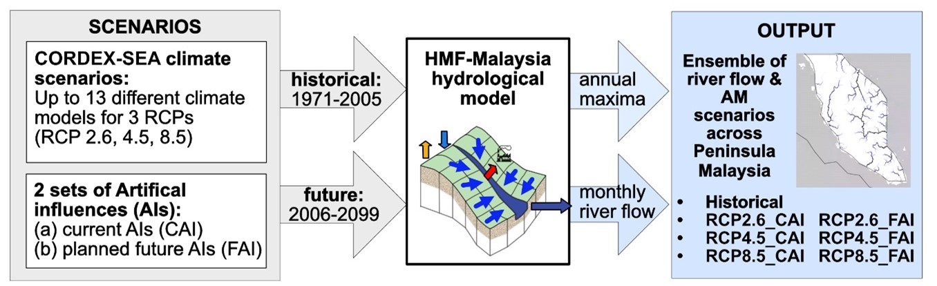
The model output displayed in the portal will be available to download in 2024.
References
Rameshwaran, P, Bell, V A, Davies, H N, Brown, M J, Zulkafli, Z, Rehan, B M, Okeke, T C. 2022. Historical (1971–2005) and projected (2006–2099) hydrological model (HMF-Malaysia) estimates of monthly mean and annual maximum river flows across Peninsular Malaysia driven by CORDEX-SEA projected climate data. NERC EDS Environmental Information Data Centre.
Additional notes
- No individual CORDEX-SEA ensemble member can be identified as being "preferred" or providing "most-reliable" projections, and thus analyses here considered the full range of ensemble percentile changes in flows modelled using CORDEX-SEA climate model output for historical and future periods.
- Present-day simulated flows are compared with projected future flows derived using the same CORDEX-SEA model.
- Individual rivers in each country can be identified from the geo-referenced gridded flows provided, but the relatively coarse spatial resolution of the flow data provided here (0.008333° × 0.008333° grid — approximate grid of 1 km × 1 km) cannot readily provide river flows for catchments below 5 km2.
- Here, daily CORDEX-SEA climate model variables from 6 RCP2.6, 7 RCP4.5 and 13 RCP8.5 ensemble members (Table 1) have been used to drive the HMF-Malaysia. RCPs refer to the Representative Concentration Pathway of greenhouse gases extending up to 2100, for which Integrated Assessment Models (IAMs) produced corresponding emission scenarios linking main features of society and economy with the Earth-biosphere and atmosphere systems into one modelling framework (van Vuuren et al., 2011):
- RCP2.6 — Radiative forcing peaks at approximately 3 Wm-2 before 2100 and then declines;
- RCP4.5 — Radiative forcing is stabilised at approximately 4.5 Wm-2 after 2100;
- RCP8.5 — Radiative forcing reaches greater than 8.5 Wm-2 by 2100 and continues to rise for some amount of time.
Acknowledgements
This dataset is an outcome of from the Malaysia — Flood Impacts Across Scales (FIAS) project supported by the United Kingdom's Natural Environment Research Council (NE/S003177/2) and Ministry of Higher Education of Malaysia (NEWTON/1/2018/WAB05/UPM/2). This web portal work is supported by the Natural Environment Research Council as part of the NC-International programme (NE/X006247/1) delivering National Capability.